On May 6th, I will be hosting a free walking tour, discussing the history of development in Downtown Miami around the River, the Train Tracks, and the Highway. We will also look to the future and see these infrastructures as potential connection points rather than boundaries.
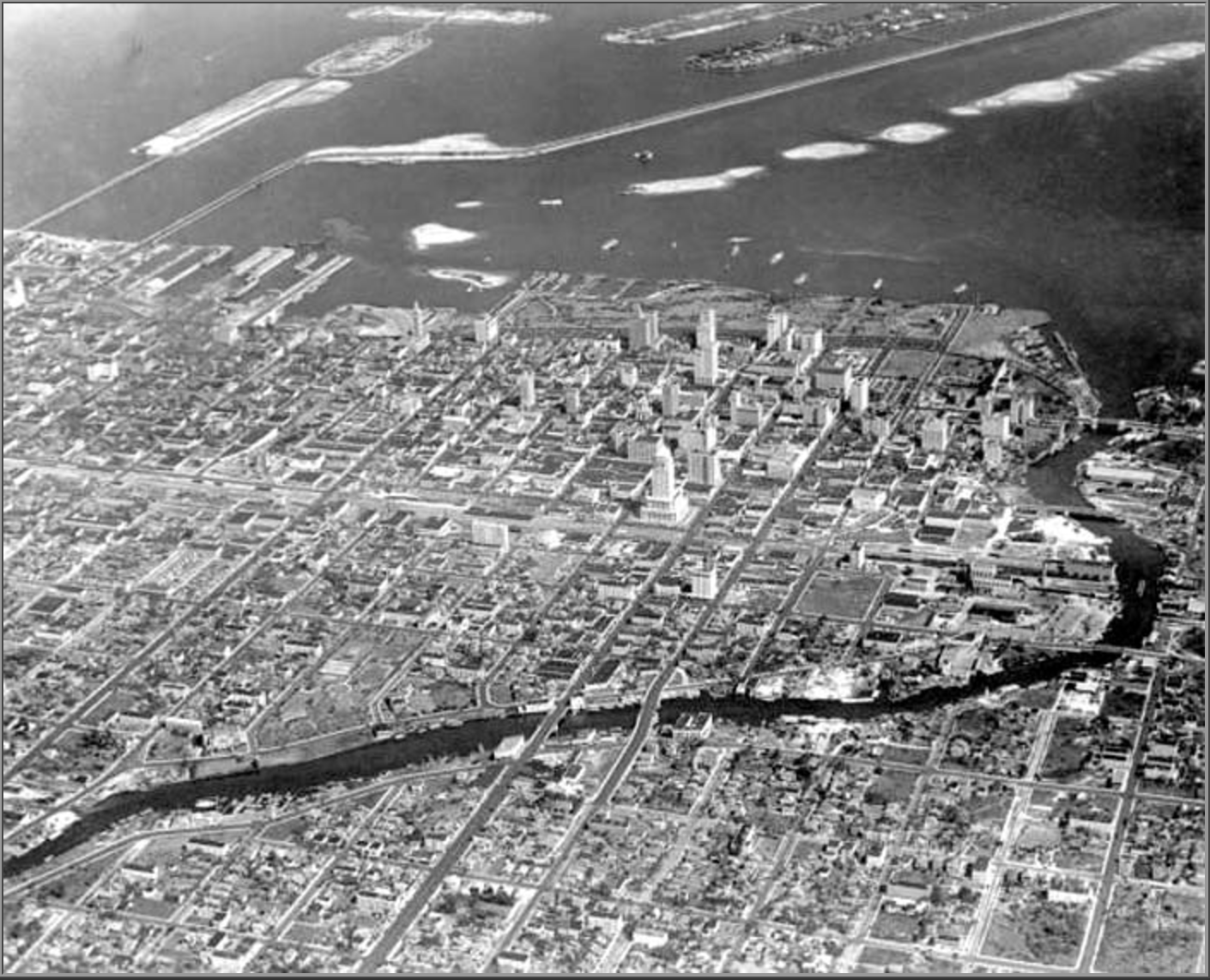
When the first settlers, the Tequesta Indians, arrived in South Florida, there was little topography to speak of. No mountains, no valleys, and no plains; only the sea, and the Miami River,originally a rapids runoff from the Everglades. It seems appropriate that the first settlers would find the north side of the mouth of this river to be an ideal location. As white settlers began to arrive in Miami, they traded with the Indians and grabbed large plots of land south of the River such as George Merrick in Coral Gables, Mary Brickell in Brickell, and the John Deering in Coconut Grove. Julia Tuttle would later grab the land the Tequesta’s originally settled on through a government purchase of Ft. Dallas (north of the River), and that would later become Miami.
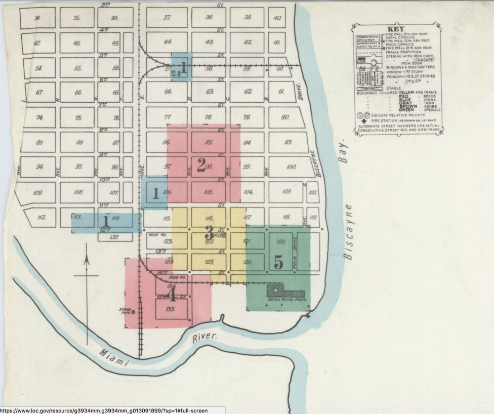
Map of Miami, 1899
This importance of the River, in establishing a boundary in the city shaped the way the city was platted, settled, and eventually built. When Julia Tuttle offered half of her land to Henry Flagler to build a rail to Miami and hotel a second boundary was established in the city in 1896. The railroad cut the city in half. At the time, segregation laws required that a “colored town” be established, so this was designated to be to the west of the Railroad and the north of the River. The sole boundaries at the time created a vibrant and bustling working-class neighborhood that would thrive.
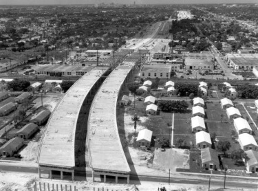
I-95 Being constructed through a housing community in “Colored Town”
Colored Town became a place of entertainment and home to the most profitable black-owned businesses in Florida. NW 2nd Ave was dubbed “Little Broadway,” and hosted artists such as Nat King Cole and Ella Fitzgerald for black and white audiences alike. A lot of workers who lived in this neighborhood came down to build Flagler’s railroad but ended up staying to work in the hospitality industry that was thriving in South Florida.
At its height, Colored Town had 50,000 residents living in it. However the Federal-Aid Highway Act of 1956 was signed, and state and federal officials built I-95 directly over the community, renaming it Overtown and effectively decimating its population, from 50,000 to just 10,000 residents.


Today these three boundaries seem to be part of the fabric of our city, but at their inceptions, they provided real effects to how we perceived, developed, and segregated ourselves. Today, the MiamiCentral station, home of the new Brighline trains, sits across 6 blocks of Downtown Miami, mimicking Flagler’s rail tracks from over 100 years before. However, unlike its predecessors, the station tries to be more than an artery but a place. Its form lifts itself off the ground with imaginative trusses that do not create an infrastructural eyesore in the city, but a place of potential gatherings. By including office space, retail, residential, and not closing off access to a single street, the project actively tries not to create a boundary but perhaps attempts to stitch these two halves of downtown together.
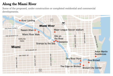
Map by the New York Times of new development along the river
Furthermore, the River is being seen more and more as an amenity, creating an artery of development instead of division. Mimicking great cities around the world such as Shanghai, New York, and London, the Miami River is becoming a gathering place and a boon for developers seeing it as a new frontier. See above for a map of new development, showing its immediate potential as an artery, and less as an industrial boundary in the city.
Are these large infrastructures Boundaries or Arteries? Of course, the answer is both, and in order for us to learn from our past mistakes, we must be cognizant of the immense effect these past decisions have had on our city. If you want to explore what this looks like in person, join us this Sunday, May 6th for a free walking tour at 11am starting at the Art Africa Miami Arts Fair Gallery, and ending with free admission to the HistoryMiami Museum!
See event details on Facebook: https://www.facebook.com/events/181452702507275/
or Eventbrite: https://www.eventbrite.com/e/miamiwalks-downtown-miamis-history-of-development-tickets-45461146513?aff=efbeventtix
—
Sources:
http://wlrn.org/post/how-i-95-shattered-world-miamis-early-overtown-residents
http://www.npr.org/templates/story/story.php?storyId=129475747
http://miamiarchives.blogspot.com/2014/01/expressway-construction-in-miami-1960s.html
http://www.miamitodaynews.com/2016/12/20/state-nears-new-395-signature-bridge-downtown/

[…] Read More […]
LikeLike